

The EMS project is funded by the European Union under the Copernicus programme and coordinated by the European Commission Joint Research Centre (JRC).
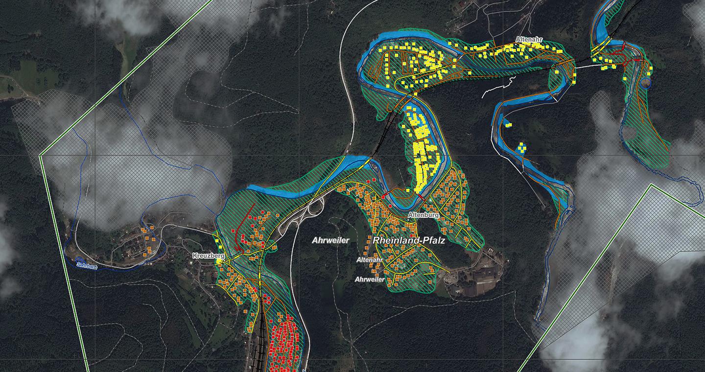
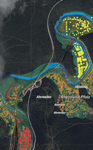
Between 13 and 15 July extremely heavy rain fell in western Germany, Belgium and the Netherlands, swelling rivers and causing tragic floods. On 16 July a fire broke out on the Greek island of Samos. A few days later, another fire broke out in Spain, near the town of Albacete: over 2500 hectares of woods were wiped out in the space of just a few hours. In the following days Sardinia, Sicily, in Italy, and other countries such as Turkey, Greece or Albania have also been tormented by fires.
As well as counting on mutual European aid in the management of these kinds of emergencies, local authorities and civil defence departments can also put their trust in the Copernicus Emergency Management Service (EMS) – Rapid Mappig (RM), the Copernicus programme service that provides rapid satellite maps of afflicted areas.
The RM is able to provide information and satellite maps anywhere in the world, 24/7/365, for all types of disasters, whether natural, meteorological or manmade. These instruments are crucial both for coordinating aid during emergencies but also preventing and mitigating potential adverse events in the future.
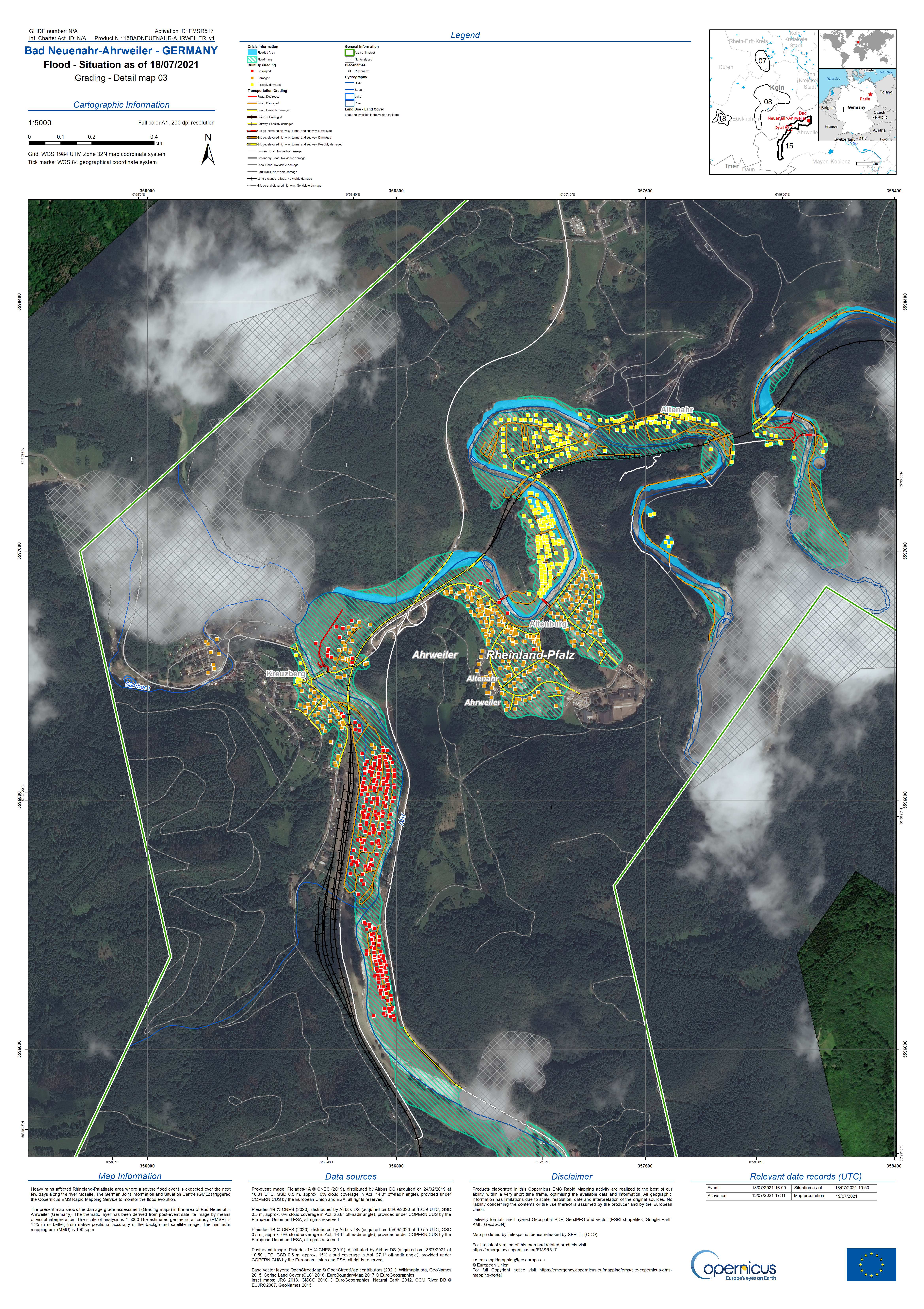
Map produced by Telespazio Ibérica
To monitor emergencies, the RM places its trust in the data of the Sentinels of the Copernicus European satellite observation programme as well as national Copernicus contributing missions, such as the Italian COSMO-SkyMed or the French SPOT missions – to name just two – which provide their data, if required.
Since its creation in 2012, the EMS – Rapid Mapping service has provided maps and information for over 520 events. The service is managed by the European Commission – JRC and the map production is entirely delegated by to an European consortium led by e-GEOS (80% owned by Telespazio, 20% by the Italian Space Agency) that also involves GAF – a 100% e-GEOS company – and Telespazio Ibérica.
Óscar Muñoz, who leads the Telespazio Ibérica team dedicated to the service, gives us an overview of the participation and values of the team involved in the project, also commenting on the role played by the company within the consortium.
Telespazio Ibérica participates in the execution of the Copernicus Emergency Management Service - Rapid Mapping, being part of the consortium led by e-Geos since February 2019, with a team of more than 20 people covering the service 365 days a year in 16 and 24-hour shifts throughout the 52 weeks of the calendar year.
During these two and a half years of service execution, Telespazio Ibérica has participated in more than 55 activations in which it has carried out all types of products in the service portfolio (First Estimation Product, Delineation, Monitoring, Grading and Reference). The company has worked on all types of natural disasters (floods, fires, earthquakes, avalanches and specific services related to the mobility of the COVID-19 pandemic). All products work with a variety of satellite, aerial (drone) and radar imagery, and with different GSD resolutions (from 0.20 m to 500 m).
The need to deliver fast response products (in times ranging from 2 to 12 hours) and the level of demand for product quality, make the team in charge of the execution of this service a multidisciplinary team, with great availability, involvement and dynamism and with a great culture of teamwork (not only internal within the Telespazio Ibérica team, but also with the teams of the other companies that are part of the consortium). These qualities are essential for the successful execution of this service, and of course, Telespazio Ibérica has a team to achieve these objectives.
For the execution of the service, there is a special area set up with exclusive equipment for the project, adapting all the software and hardware to the requirements of the project.